Our Solution: LandsatConnect App

HIGH LEVEL SUMMARY
Landsat Connect is a web-app designed to provide a quick, simple and intuitive way to track Landsat satellites and access Landsat Surface Reflectance (SR) data, fostering interdisciplinary and scientific learning skills and empower citizens. End-users can quickly set a target location and receive notifications in advance of when the Landsat satellite will pass over the areas, allowing users to prepare and take their own ground-based measurements, obtaining the pixel data that is relevant to them without the need to constantly monitor satellite schedules. Landsat Connect is designed with accessibility in mind, ensuring that users of varying technical levels and abilities, including those with disabilities, can benefit from it.
PROJECT DEMO
PROJECT DETAILS
Landsat Connect is designed to simplify the process of accessing Landsat Surface Reflectance (SR) data. With a user friendly interface and customizable features, the application caters to users of different technical levels. The following are the main components driving the application:
USER LOCATION MANAGEMENT

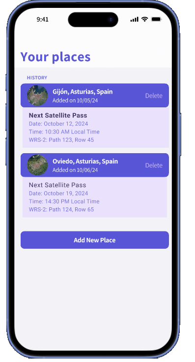
The user will be able to add more locations thanks to an intuitive screen where they will be able to pinpoint in a map their desired location or introduce the longitude and latitude of the location. This feature allows the user to monitor multiple areas at the same time.Each user will be able to create and store multiple locations to receive notifications from.
AUTOMATED NOTIFICATIONS

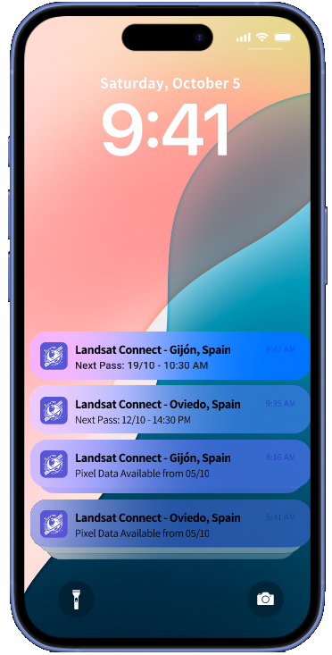
The application will notify the user ahead of time about the Landsat’s next scene in their desired locations. Landsat Connect allows users to choose their preferred notification lead time for satellite overpass and select their desired notification method (email, SMS or push notification), providing flexibility and ensuring the service is tailored to their specific needs.
The App also notifies the user once the Surface Reflectance Data is available for that location so that the user can compare the data as close to real time as possible.
ACCESS TO LANDSAT SURFACE REFLECTANCE (SR) DATA

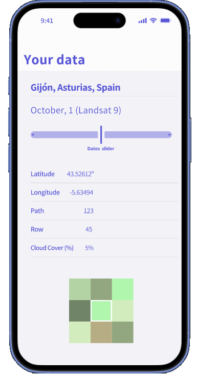
Once Landsat obtains and processes the data it can be fetched and made available for visualization and download in Landsat Connect. The user can choose between a single instance of the data from a certain date or determine a time span, the cloud coverage threshold can be set to filter the results. The data is also available to download for offline use.
It will display a 3x3 pixel grid where the desired location will be the center pixel and the others will be used as context. Landsat Connect will provide the relevant metadata from the pixel such as date, time, latitude, longitude, path, row, etc combined with a spectral signature graph of the Landsat Surface Reflectance (SR) data. In addition, you will have access to detailed satellite images such as infrared or vegetarian analysis.
Users can export the obtained data in useful formats such as CSV or PDF to obtain a report of the data. This data obtained is formatted and ready for external analysis with ground-based measurements.
USE CASES FOR LANDSAT CONNECT
Agricultural Monitoring
- User: Farmers and agricultural consultants.
- Scenario: A farmer wants to monitor crop health and soil moisture levels to optimize irrigation and detect early signs of disease. Using Landsat Connect, they can pin their field’s location and receive notifications when Landsat will pass over, allowing them to gather real-time insights. By comparing satellite imagery with on-ground measurements, farmers can make timely decisions on crop treatment and irrigation schedules.
Environmental Research and Conservation
- User: Environmental scientists and conservationists.
- Scenario: Researchers studying deforestation or habitat loss in a remote area need timely satellite data to track changes over time. Landsat Connect enables them to mark multiple locations and receive regular pass notifications. With offline capabilities, they can save historical data, even in areas without internet connection, and conduct longitudinal studies with improved accuracy.
Urban Planning and Development
- User: Urban planners, city governments, and development authorities.
- Scenario: A city planner needs to monitor urban expansion and green cover reduction over time. By receiving Landsat pass alerts, planners can track developments and view historical images in specific areas to study growth patterns, inform zoning policies, and plan green spaces, ensuring sustainable urban development.
TECHNICAL EXPLANATION
Project Architecture
- Backend: Built with Django framework based on Python, leveraging Django’s flexibility, scalability, and suitability for data-intensive applications, especially for data science and environmental monitoring. Django will manage user requests, authentication, and notification logic.
- Data Integration: Using API to get data from Landsat , the backend processes and schedules Landsat satellite overpasses based on each user’s specified location.
- Frontend: Designed as a responsive web application compatible with all devices (desktop, tablet, and mobile) to provide flexibility. It will include an interactive map where users can pin locations and configure alerts.
- Database: A database will store user locations, satellite pass schedules, and historical data for offline access. We’re also incorporating caching to ensure low-latency notification delivery and efficient data retrieval.
- Offline Mode: Data caching and storage features allow users to save satellite data and notifications locally, enabling offline usage in areas with limited connectivity.
Notification System: The app will notify users via email, SMS, or in-app pop-ups (push notifications for mobile users) about upcoming satellite passes. The backend will automate notification scheduling based on Landsat’s orbit and each user's location, ensuring alerts arrive precisely when needed.
Scalability & Extensibility: The Django framework provides scalability and extensibility for future enhancements, such as integrating additional satellites, more advanced image analysis tools, and expanded offline features. This allows Landsat Connect to be a versatile tool for various use cases across agriculture, environmental science and urban planning.
Diversity, Inclusion, and Accessibility: Landsat Connect is prioritizing accessibility, we ensure that all users, regardless of their sensory abilities, can navigate and utilize the app's full functionality with ease, the app includes:
- Language Localization: Support for multiple languages, enhancing accessibility for non-English speakers.
- Accessible Design: Adherence to WCAG 2.1 guidelines ensures compatibility with screen readers, color contrast adjustments, and intuitive keyboard navigation for users with varying abilities.
- Universal Usability: Simplified and consistent design makes the app easy to navigate for users with minimal tech experience. Clear labels, accessible icons, and customizable notification types foster an inclusive experience across educational, professional and geographical backgrounds.
USE OF ARTIFICIAL INTELLIGENCE
We used AI as a tool to understand the technical problem of the project. Hence, accelerating the creation of our solution by comparing multiple solutions at once. Furthermore, we used Microsoft Designer to create the logo of the team and invideo.io to voice over the project video.
- ChatGPT
- Invideo.io
- Claude.ai
- Microsoft Designer
